Day 6 (Pike's Peak)
Day 6
June 27, 2006
Sightseeing in Colorado Springs
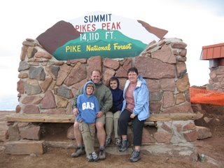
We set out for Pike’s Peak by car in the early morning. We paid $30 and were given a map that showed a 19-mile-long road that climbed 8,000 feet elevation. The upper portion of the road was dirt. We saw only 2 sections of guardrail the whole way. The most surprising thing to us was the difference in temperature between the base and summit. It was 40 degrees colder at the top (37 versus 77). We even saw some snow flurries while walking around up there!
The views were awesome. We could see for miles in every direction, including views of several lakes and reservoirs below. The valley floor east of Colorado Springs looked just like the scenery one would typically see out the window of an airplane.

While on the way up to the summit, we passed the timber line at about 12,000 feet. Above that point we all remarked at how much the terrain, landscape and weather reminded us of Iceland.
We felt some effects from the altitude, primarily some lightheadedness if we moved around too quickly. Everyone there seemed to be walking slowly, like COPDers normally do.
While driving up the road to the top, I received a phone call from the manager at the Welcome Center saying that a stranger, no doubt one with Midwest morals, found the camera in the men’s bathroom and turned it into the volunteer staff. I quickly called Don Stewart in Flagstaff and asked him if I could have the camera shipped to his house where we plan to be on July 7. He agreed, so I called the welcome center back and they said they will mail it to Don’s house. What a relief that was!
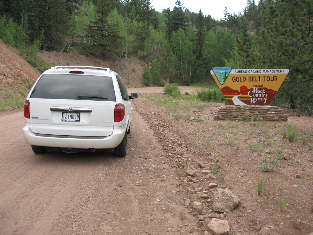
We then drove part of a scenic loop na med the Gold Belt Tour that includes Phantom Canyon Road as one of its legs. Phantom Canyon Road can only be described as a highway engineering masterpiece. It is a dirt, mostly 1 lane with some 2-lane sections, twisting, winding track that goes for 25 miles up, down, over and through (tunnels) some of the most rugged canyon lands any of us had ever seen. In places it was only 15 feet between sheer vertical stone walls. Spectacular! Both kids thought it was better than Pike’s Peak.
We next drove to Royal Gorge to see the World’s highest suspension bridge (just over 1000 feet above the Arkansas River). In a word, this was disappointing. We were charged $50 for a 1-hour look at the bridge, including the rights to walk and drive across it. The town that owns the bridge has made it into a cheesy tourist trap. The only reason we paid 50 bucks to walk across a bridge was that we drove so darn far to get to it. Today we drove more than 230 miles, 80 miles of it at 20 MPH or slower! Tomorrow we all agree no more long rides in the car!
June 27, 2006
Sightseeing in Colorado Springs

We set out for Pike’s Peak by car in the early morning. We paid $30 and were given a map that showed a 19-mile-long road that climbed 8,000 feet elevation. The upper portion of the road was dirt. We saw only 2 sections of guardrail the whole way. The most surprising thing to us was the difference in temperature between the base and summit. It was 40 degrees colder at the top (37 versus 77). We even saw some snow flurries while walking around up there!
The views were awesome. We could see for miles in every direction, including views of several lakes and reservoirs below. The valley floor east of Colorado Springs looked just like the scenery one would typically see out the window of an airplane.

While on the way up to the summit, we passed the timber line at about 12,000 feet. Above that point we all remarked at how much the terrain, landscape and weather reminded us of Iceland.
We felt some effects from the altitude, primarily some lightheadedness if we moved around too quickly. Everyone there seemed to be walking slowly, like COPDers normally do.
While driving up the road to the top, I received a phone call from the manager at the Welcome Center saying that a stranger, no doubt one with Midwest morals, found the camera in the men’s bathroom and turned it into the volunteer staff. I quickly called Don Stewart in Flagstaff and asked him if I could have the camera shipped to his house where we plan to be on July 7. He agreed, so I called the welcome center back and they said they will mail it to Don’s house. What a relief that was!
We then drove part of a scenic loop na
 med the Gold Belt Tour that includes Phantom Canyon Road as one of its legs. Phantom Canyon Road can only be described as a highway engineering masterpiece. It is a dirt, mostly 1 lane with some 2-lane sections, twisting, winding track that goes for 25 miles up, down, over and through (tunnels) some of the most rugged canyon lands any of us had ever seen. In places it was only 15 feet between sheer vertical stone walls. Spectacular! Both kids thought it was better than Pike’s Peak.
We next drove to Royal Gorge to see the World’s highest suspension bridge (just over 1000 feet above the Arkansas River). In a word, this was disappointing. We were charged $50 for a 1-hour look at the bridge, including the rights to walk and drive across it. The town that owns the bridge has made it into a cheesy tourist trap. The only reason we paid 50 bucks to walk across a bridge was that we drove so darn far to get to it. Today we drove more than 230 miles, 80 miles of it at 20 MPH or slower! Tomorrow we all agree no more long rides in the car!
posted by Hazzard Family | 15:50
|
3 comments
![]()