Day 47 (Is it a C or a W?)
Day 47
August 7, 2006
Mackinac Island
 Mackinac Island is a wonderful mix of Disney World (pristine streets, impeccable landscaping and no vehicular traffic), Bar Harbor (seasonal tourist town), Mount Vernon (bicycle trails everywhere), Seattle (hydro-jet ferries zipping around), Williamsburg (horses used for labor and people roaming around in period clothing), Price Edward Island (pebble-covered “beaches” where Nordic peoples who apparently had never been
  to a proper beach were swimming in cool water and having the times of their lives), and Newport (waterfront wood-frame buildings).
We set out across “The Straits” with almost no preconceptions about what we would find on the other side. The trip via hydro-jet ferry at 27 knots took about 25 minutes. At the kids’ suggestion, we took seats on the open, second deck where we were treated to some very gusty winds and occasional water spray as our boat rolled and rocked its way along under mostly sunny skies and an air temperature of 70 degrees.
 Beginning with our first glimpse of the Island we were impressed. The place has character with a capital C. Basically it’s a small island, heavily forested except for where a small town exists, with a one-lane-wide paved road around its circumference that has been divided into two lanes for use by bicycles and horse-drawn wagons. The town is two streets deep by eight streets wide. There are a number of very nice hotels and B and Bs in town, each smartly painted and landscaped to the hilt with flowers.
  For about three blocks along the water where the ferries come in, there is a flurry of activity including young men toting carts by hand with luggage and other stuffs on them. Horse transportation is big on Mackinac. There are horse-drawn taxis, tours, garbage wagons and even a UPS wagon!
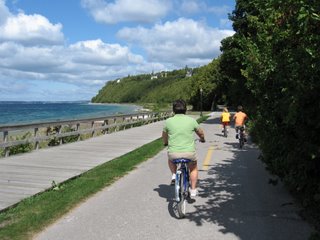
We rented bikes and rode around the island’s perimeter (eight miles). It was mostly flat, but not entirely. The highest point on Mackinac Island is about 320 feet above Lake Huron level (577 feet). At one point we stopped to take some photos of Arch Rock, a “window” rock through which we could see the bike path below us and Lake Huron beyond it—very picturesque. After finishing the loop around Mackinac’s perimeter, we rode around through the streets of the town and up to Fort Mackinac, which dates back to 1779.
We ate lunch in Mary’s Bistro, which advertised “an eclectic mix” of foods. The food was good, but the portions were a bit small, especially after riding bikes for two hours.
 We spent the next few hours shopping, although we quickly realized that there wasn’t much for sale except fudge and tacky tee shirts. Frank almost bought the one that said “My Indian name is Drinks the Beer,” but Sessy vetoed the purchase. Given the ambiance of the town, we were disappointed in the quality of the stores.
Even Frank, known for his poor spelling, noticed that “Mackinac (Mackinaw)” is spelled two ways, so, being the inquisitive guy that he is, he had to ask why. If you are not as inquisitive, you may want to skip the following paragraph.
 The Native Americans who lived on the northern tip of what is now the Lower Peninsula of Michigan named the area, including the Straits and Island “Michinni-Makinong.” We don’t know the literal translation, but we’re pretty sure it meant “windy, cold lake lands.” When the French came, they butchered the Indian name and started calling things “Mackinac.” When the English followed, they bastardized the name a little more with a phonetic spelling, “Mackinaw.” Today, the only name with a W is the town on the main land, Mackinaw City; everything else uses the C.
Emily was the only member of the family who wanted to swim in Lake Huron (no surprise!) She said it was warm once you got used to it. We were surprised by the cleanliness and color of the water. It was Destin-like with its shades of aqua.
August 7, 2006
Mackinac Island
 Mackinac Island is a wonderful mix of Disney World (pristine streets, impeccable landscaping and no vehicular traffic), Bar Harbor (seasonal tourist town), Mount Vernon (bicycle trails everywhere), Seattle (hydro-jet ferries zipping around), Williamsburg (horses used for labor and people roaming around in period clothing), Price Edward Island (pebble-covered “beaches” where Nordic peoples who apparently had never been
  to a proper beach were swimming in cool water and having the times of their lives), and Newport (waterfront wood-frame buildings).
We set out across “The Straits” with almost no preconceptions about what we would find on the other side. The trip via hydro-jet ferry at 27 knots took about 25 minutes. At the kids’ suggestion, we took seats on the open, second deck where we were treated to some very gusty winds and occasional water spray as our boat rolled and rocked its way along under mostly sunny skies and an air temperature of 70 degrees.
 Beginning with our first glimpse of the Island we were impressed. The place has character with a capital C. Basically it’s a small island, heavily forested except for where a small town exists, with a one-lane-wide paved road around its circumference that has been divided into two lanes for use by bicycles and horse-drawn wagons. The town is two streets deep by eight streets wide. There are a number of very nice hotels and B and Bs in town, each smartly painted and landscaped to the hilt with flowers.
  For about three blocks along the water where the ferries come in, there is a flurry of activity including young men toting carts by hand with luggage and other stuffs on them. Horse transportation is big on Mackinac. There are horse-drawn taxis, tours, garbage wagons and even a UPS wagon!
We rented bikes and rode around the island’s
 perimeter (eight miles). It was mostly flat, but not entirely. The highest point on Mackinac Island is about 320 feet above Lake Huron level (577 feet). At one point we stopped to take some photos of Arch Rock, a “window” rock through which we could see the bike path below us and Lake Huron beyond it—very picturesque. After finishing the loop around Mackinac’s perimeter, we rode around through the streets of the town and up to Fort Mackinac, which dates back to 1779.
We ate lunch in Mary’s Bistro, which advertised “an eclectic mix” of foods. The food was good, but the portions were a bit small, especially after riding bikes for two hours.
 We spent the next few hours shopping, although we quickly realized that there wasn’t much for sale except fudge and tacky tee shirts. Frank almost bought the one that said “My Indian name is Drinks the Beer,” but Sessy vetoed the purchase. Given the ambiance of the town, we were disappointed in the quality of the stores.
Even Frank, known for his poor spelling, noticed that “Mackinac (Mackinaw)” is spelled two ways, so, being the inquisitive guy that he is, he had to ask why. If you are not as inquisitive, you may want to skip the following paragraph.
 The Native Americans who lived on the northern tip of what is now the Lower Peninsula of Michigan named the area, including the Straits and Island “Michinni-Makinong.” We don’t know the literal translation, but we’re pretty sure it meant “windy, cold lake lands.” When the French came, they butchered the Indian name and started calling things “Mackinac.” When the English followed, they bastardized the name a little more with a phonetic spelling, “Mackinaw.” Today, the only name with a W is the town on the main land, Mackinaw City; everything else uses the C.
Emily was the only member of the family who wanted to swim in Lake Huron (no surprise!) She said it was warm once you got used to it. We were surprised by the cleanliness and color of the water. It was Destin-like with its shades of aqua.


0 Comments:
Post a Comment
<< Home